GéoCatalogue de l'UMR LISAH
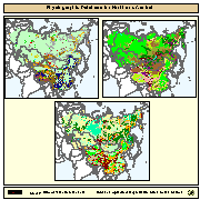
Physiographic Map of North and Central Eurasia (Sample record, please remove!)
Simple
- Date ( Publication )
- 1999-10-01
- Edition
- First
- Forme de la présentation
- Carte numérique
- Etat
- Finalisé
- Fréquence de mise à jour
- Lorsque nécessaire
- Mots clés ( Thème )
-
- physiography, soil
- Mots clés ( Localisation )
-
- Eurasia
- Contraintes d'accès
- Droit d’auteur / Droit moral (copyright)
- Contraintes d'utilisation
- Droit d’auteur / Droit moral (copyright)
- Type de représentation spatiale
- Vecteur
- Dénominateur de l'échelle
- 5000000
- Jeu de caractères
- Utf8
- Catégorie ISO
-
- Geoscientific information
- Date de début
- 2000-01-01T04:29:00
- Date de fin
- 2008-01-08T04:29:00
))
- Informations supplémentaires
- The maps are included in the SOIL and TERRAIN Database for Northern and Central EURASIA CD-ROM , which contains also the Soil map of North and Central Eurasia, reports and databases. Copies of this CD-Rom can be ordered from: Sales and Marketing Group FAO, Viale delle Terme di Caracalla, 00153 Rome, or by email to Publications-sales@fao.org. The terms and definitions used in the Physiographic database are based on the procedures manual for ?Global and National Soils and Terrain Digital Databases (SOTER)?, prepared by UNEP, ISSS, ISRIC and FAO and published by FAO as World Soil Resources Report #74 Rev1 (1995). Refinements were made in China as part of the preparation of a physiographic map for Asia, work carried out by G. van Lynden for FAO as part of the ASSOD project.
- Nom du système de référence
- Lambert Azimuthal Projection
- Niveau topologie
- Spaghetti
- Type de géométries des objets
- Complexe
- Ressource en ligne
-
phy.zip
(
WWW:DOWNLOAD-1.0-http--download
)
Physiography of North and Central Eurasia Landform (Gif Format)
- Ressource en ligne
-
GEONETWORK:phy_landf_7386
(
OGC:WMS
)
Physiography of North and Central Eurasia Landform
- Ressource en ligne
-
GEONETWORK:phy_slope_7386
(
OGC:WMS
)
Physiography of North and Central Eurasia Slope
- Ressource en ligne
-
GEONETWORK:phy_hypso_7386
(
OGC:WMS
)
Physiography of North and Central Eurasia Hypsography
- Niveau
- Jeu de données
gmd:MD_Metadata
- Identifiant de la fiche
- 78f93047-74f8-4419-ac3d-fc62e4b0477b XML
- Jeu de caractères
- Utf8
- Date des métadonnées
- 2007-11-06T12:10:47
- Nom du standard de métadonnées
- ISO 19115:2003/19139
- Version du standard de métadonnées
- 1.0
Aperçus

Fourni par